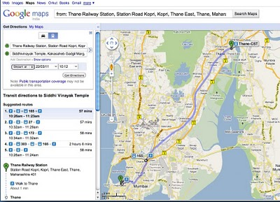
Google Maps already provides Metro routes in Delhi & transit information for their users in Bangalore & Pune. The same transit information is now available to Mumbai users with Google maps offering information about BEST buses & the infamous Mumbai local train system.
The system lets anyone to look for routes from one place to another in Mumbai and find transit information in the route. This is a great feature for people in Mumbai as well as tourists visiting Mumbai.

How to use Google Transit ?
Search for information to reach from Place A to B on Google Maps
- The result shows a map with the possible route and driving directions for the commuter
- Choose the transit option by clicking the train icon (next to the car icon)
- Commuters would get first hand information on available routes and the step by step directions including frequency, and travel duration for each leg of the trip in text and on the map.
Here are a couple of searches you can try out:
[via Google India Blog]


One response to “Google Transit now available for Mumbai BEST buses & local trains”
This seems to be too generic even though its quite powerful.
I tried a search from Bhatia Hospital to Churchgate Station which gave me only 1 bus.
I tried the same search on http://www.mesn.org/bestbus and it gave me so many other buses, plus it has other options tuned better for the BEST system.
Google’s system is tailored around foreign markets whereas the mesn.org/bestbus systems seems tailored to our cities.
It also has options like just entering a destination when you are at a stop and seeing the buses that reach that destination to quickly see if any of those buses are near you.
It also shows you a stop list and help you get down at your stop if your phone has GPS.
Since Android phones are available for around 8k now and you can get GPRS for less than Rs.100 a month, for regular bus users, this should not be an issue after a few months.